 |
|
AIRSPACE
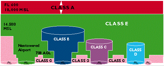
Airspace is classified according to a lettering system. Even though we are not allowed into Classes A, B, C, D, Restricted or Prohibited Areas, we are allowed into nearly all of Class E and all of Class G airspace. (as per FAR 103) After you are done with this tutorial, a great online source of current sectionals for anywhere in the country is located at this site . The Federal Aviation Administration is the federal agency responsible to regulate aviation within the US. Most hang gliders meet the requirements to operate as unpowered ultralight vehicles and as such benefit from having very little in the way of regulations to follow. Along with not needing aircraft inspections or licenses to fly them, we are allowed to fly in most areas. Learn more about the FAA. Class A airspace is not shown on your sectional. It covers the entire nation, so all we have to remember is that its lower limit is 18,000 MSL. The term "controlled airspace," by the way, doesn't mean that somebody or some agency is up there controlling traffic, but controllers have a pretty good idea of what is up there. Use of our national air traffic control (ATC) service is mandatory in Class A airspace that begins at 18,000 feet MSL and extends upward to 60,000 feet MSL. Altitudes at 18,000 feet MSL and above, in Class A airspace, are commonly referred to in hundreds of feet as "Fight Levels," abbreviated FL. For example, flight level two zero zero, or FL 200 = 20,000 feet MSL, FL 600 = 60,000 feet MSL, etc. The United States, of course, does not own or control airspace outside its territorial limits, but our government has extended Class A airspace out to twelve miles from the coast of the contiguous 48 states and Alaska. By the way, if you fly into Mexico or Canada, or if you want to rent an ultralight overseas, do not assume that you understand their airspace system. It will be similar, but homework is required. Memory aid: Class A airspace = Above, as in 18,000 and Above, as in high Above everything else. Class B Airspace: Class B airspace surrounds the nation's busiest airports and usually goes as high as 10,000 feet MSL, in some cases even higher. The uppermost level of Class B airspace may extend horizontally with radius of up to a 15 nautical miles around the airport tower. There is, however, no universal set of Class B dimensions since the flow of traffic, geography and other considerations determine the exact architecture of each Class B area. A sectional or a VFR Terminal Area Chart is very helpful in understanding the design and lateral dimensions of each Class B airspace. Theoretically, an ultralight might fly above Class B airspace, but that could be extremely dangerous. Besides, you might be flying over a congested ground area and, in certain areas, through relatively congested airspace as other aircraft are funneled through narrow approach and departure routes. On your sectional, horizontal Class B airspace limits are outlined in concentric solid blue circular lines that may be indented or extended in certain places due to geography or air traffic routes. The top and bottom of each layer of airspace, as you can see, are given in what looks like a fraction; for example, 90/40.
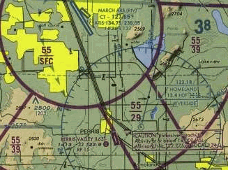
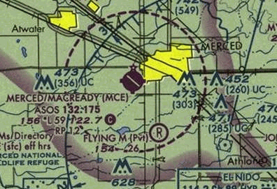
Check your sectional and you will find that the surface area of a city lying in Class B airspace is colored yellow as are all cities on the sectional. Obviously, this is what the FAA would call "congested" area, and ultralights may not fly over congested areas even if they were not in Class B or other controlled airspace. Visual clues and good judgment are your best guides for avoiding ground congestion. Even though ultralights are not permitted in class B airspace without prior permission, some operators have reported that ATC has granted permission for individual flights. Many of the fields and airparks where ultralights fly are under overhanging layers of Class B airspace. If they fly too high, or if they fly just above the surface toward a major city airport, the ultralight will penetrate the Class B airspace, and that may set off lots of alarm bells with the FAA. The inner circle of Class B airspace extends all the way to the surface. The outskirts of cities like Portland, Oregon and Seattle, Washington are surrounded by many delightful strips where small planes and ultralights fly, and their pilots know pretty well what to avoid in terms of location and altitude. Pilots who fly near major Class B airports may prefer to use a VFR Terminal Area Chart since these depict a smaller area with much more detail using a scale of 1:250,000. If you fly from a field that is under or near Class B airspace, you should study your sectional or Terminal Area Chart to memorize landmarks that might help you recognize the locations and altitudes of various sections of Class B space. Intruding into Class B airspace in an extremely serious matter. You may endanger the lives of many others since a fully loaded passenger jet carries hundreds of people. While a violation of Class D or Surface Area Class E space (discussed below) might bring only a strong lecture, a violation of Class B or Class C will almost certainly bring strong penalties. In your memory, let B stand for Big Time or Big City airspace. Class C Airspace: On your sectional, horizontal Class C limits are shown by solid magenta lines. It is similar in layout to Class B but in magenta not blue.
If "B" stands for "Big Cities," let "C" simply stand for Cities. The cities under class C airspace are our mid-sized cities. The towers at these fields are equipped with radar -- something that smaller controlled fields (Class D airspace) do not have. Ultralights may not fly in Class C airspace without special permission from ATC, and that should be obtained in advance by telephone (although some controllers will accept a radio call). Although the city involved may not be as big as New York or Washington, D.C., it will usually have heavy jet and commercial traffic coming and going. Class D Airspace: Small city airports with control towers are usually designated as Class D airspace. Associate "D" with "Diminutive" or "Dime-sized" cities if you like, and do not go there without permission either. Commercial and other IFR traffic may be flying into these fields, and there is often much general aviation activity and pilot training. Look over your sectional and find several Class D fields. The field silhouette itself (not the city) will be pictured in blue -- as all controlled fields are -- with a dashed blue circle around it. By now you have probably noticed that the runways of any airport are drawn to show their direction in terms of the compass, and that runway length is also given. There is more information to look for as well, but back to Class D airspace.
Flying over Class D airspace may not pose problems for the experienced ultralighter unless it violates the rule that ultralights must avoid flying over congested areas on the ground. It is customary for general aviation traffic that is just passing over or near a Class D field, but not planning to land there, to call the tower (the frequency is on the sectional). Such a courtesy call lets ATC know there is traffic out there in the general vicinity. Remember, a Class D airspace tower may have no radar and may, except for the controllers' eyes, be blind. If you have an aircraft frequency radio and understand radio communication procedures, it may be wise to inform a nearby Class D tower where you are and where you plan to go. Class E Airspace: Controlled airspace is officially defined by exclusion, which often does not tell you much. By that reasoning, Class E airspace is controlled airspace that is not Class A, B, C or D or G (explained below) airspace. Not too helpful, but you can be sure that there is a lot of Class E airspace, so much that one could think of it as "E" for Elemental or Everywhere airspace, the airspace out of which all other types are carved. It is the filler that fills in under Class A, ie; below 18,000' msl, and between Classes B,C and D and over the top of Class G (described below). Its volume is vast. If we ignore the upper cover of Class A airspace, it is safe to say that there is a lot more E than all the other kinds combined. Ultralights fly freely in most of Class E space with one exception described below.
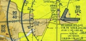
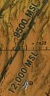
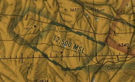
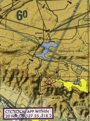
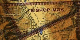
The major exception to ultralights being allowed in Class E Airspace is: FAR, Part 103.17 -- "No person may operate an ultralight vehicle within [snip] the lateral boundaries of the surface area of Class E airspace designated for an airport unless that person has prior authorization from the ATC facility having jurisdiction over that airspace." "Class E Surface Area," looks much like Class D but only in dashed magenta, not dashed blue. Notice there is no upper altitude number within a box like there was in Class D. The question then becomes... what is the upper limit? How is this airspace boundary defined? The FAA has a definition for "Class E Surface Area" that includes an upper limit. It is the height of the surrounding Class E floor just outside the lateral boundaries of the Class E Surface Area. For example in the image (above right), the upper limit of Class E Surface Area is 700' agl meaning you could fly your ultralight vehicle over this airport but you must remain at least 700' agl as you fly over. For reference on this please go to this FAA document.
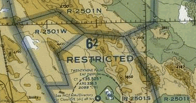
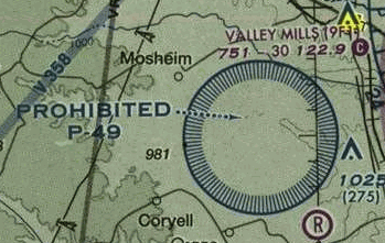
Class G airspace: Class G airspace is a mantle of low lying airspace beginning at the surface. Class G is airspace that is completely uncontrolled and in which an ultralight flies most comfortably. This low lying blanket of uncontrolled airspace only ends when it meets Class B, C, D or E airspace. Think of Class G as "ground" airspace. It covers almost the entire country. In very remote areas it has an upper limit at 14,500' msl. However the vast majority of area of the country it has an upper limit that follows the contour of the ground. The top of Class G usually is where the floor of the overriding Class E is. Like a coat of paint following the contour of the land. Sometimes the depth of Class G is 700', some times it's 1200', and where Class B,C,D or E extend to the surface there is no surface Class G. Special Use Airspace: FAR 103.17 says we are not allowed into Restricted or Prohibited areas.
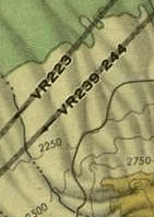
Victor Airway -- A Victor Airway is a special kind of Class E airspace.
Warning Area -- This is a hazardous area that lies over international waters, beyond the three mile coastal limit. Long, over water flights by ultralights into these areas are unlikely.
Alert Area -- Bordered the same as a Restriced and Prohibited area, the identifier is not with a R or P but with an A. We are allowed into Alert Area without prior permission. An Alert Area may involve high general aviation traffic, unusual air operations or frequent student training. The area will be marked with a blue border with a word or two of explanation. Things Change -- Presidents and other important people who require high security show up everywhere from time to time, air shows open and close, natural disasters (like forest fires) suddenly command attention, runways close for repairs, etc. Be aware of current events in your area, events that might change airspace demands. If you have a question, a call to your local Flight Service Station will answer it. 1(800) WX-BRIEF. Ask for any NOTAMS that may affect flying under Part 103. An online source for Temporary Flight Restrictions is available at this website. |